


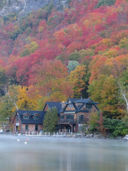
I got gas and my first cup of coffee in Lyndonville. I took Rt5 to Rt 5A to the south end of Lake Willoughby. Because of my early departure, I arrived before sunrise.


The foliage was outstanding. Everywhere I look there was color. Here are a couple overhead pictures looking down on the dirt roads I was driving on.


I stopped Mollie Beattie Bog. I walked to the end of the wheelchair-accessible path and took pictures. They say it is one of the most significant black spruce woodland bogs in Vermont and contains one of the largest populations of bog sedge, which is a rare plant in Vermont. When taking these pictures, I noticed some unusual spider webs on some trees. Interesting with the condensation on the web. Couldn’t see the spiders though.


I went to Lewis Pond. It was beautiful and so peaceful. They built a wheelchair-accessible path through the woods to the pond. I wish I could have stayed there longer but I wanted to keep exploring.


I continued exploring the dirt roads and eventually headed back to Island Pond. I took Rt114N toward Norton to the Hurricane Brook area. More dirt roads and trails.


From there, back South to Rt111 toward Morgan. I took several barn pictures along the way. I saw some horses and seemed to make a friend with this one.


I decided at that point to head toward Holland Pond. On my way, there were trucks, combines, and tractors busy with cutting corn and hay. I stopped to take a few pictures cutting the corn. It was fun to watch. Reminded me of the family farm in Iowa I would visit when I was younger.


I continued to Holland Pond. The road went right to the Canadian border before turning east. Going east there were posted signs marking the Canadian border along the edge of several fields. I took several pictures of Holland Pond.


I decided mid-afternoon to head to Peacham, VT. My GPS sent me West along the border to I91S. As I approached the main border crossing at
I91, I saw multiple border patrol agents on the roads. I made sure I didn’t accidentally turn North and
go over the border to cause an international incident. Hehe …
I took I91S to Rt2W toward Peacham. Peacham has a pretty church and Barn in the center of town. When I arrived, there were 4 or 5 cars parked and people on the hill taking pictures. That seems to be a picture hot spot. While taking a few pictures with my drone I could see a couple other farms in the distance, so I drove to them and took a few more pictures.


From Peacham, I decided to start to head toward home. Making my way to Rt5S, I headed toward I89. I stopped at a round barn in Woodsville and took a couple pictures. After Woodsville it was starting to get dark, so I decided to jump on I91S to I89S for a quick drive home.


Once on I89S, I stopped for Gas in Lebanon. When I merged on to I93S in Concord, NH, the
traffic going northbound was all backed up and slow-moving. They were heading North to leaf peep. I made the right call doing the Friday
thing. Home just after 9:00PM.
I had to take a couple Intentional Camera Movement (ICM) pictures. I like them. Pam doesn't. Oh well.


I love taking pictures but several times while driving I regretted not having anyone with me to share the experience. Over 500 miles, lots of pictures, spectacular
views while driving the back roads in the Northeast Kingdom, and the foliage … OH
MY …
Click on the pictures to enlarge.


